Yandex Cloud
  • Services
  • Solutions
  • Why Yandex Cloud
  • Blog
  • Pricing
  • Documentation
  • Contact us
Get started
Language / Region
Yandex project
© 2023 Yandex.Cloud LLC
Yandex DataLens
  • Getting started
  • Practical guidelines
    • All tutorials
    • Visualizing data from a CSV file
    • Creating and publishing a chart with a map of Moscow from a CSV file
    • Analyzing a retail chain's sales from a ClickHouse database
    • Analyzing public data on road accidents in Russia
    • Analyzing sales and locations of pizzerias based on data from ClickHouse DB and Marketplace
    • Web analytics with a connection to Yandex Metrica
    • Web analytics with funnels and cohorts calculated based on Yandex Metrica data
    • Mobile app analytics based on AppMetrica data
    • Analyzing Yandex Music podcast statistics (for podcasters)
    • Visualizing data with a QL chart
    • Visualizing data using parameters
    • Visualizing Yandex Monitoring data
    • Building customer journey charts based on AppMetrica data
  • Concepts
    • Service overview
    • Organizations in DataLens
    • Connection
    • Data types
    • Datasets
      • Overview
      • Data model
      • Dataset settings
    • Charts
      • Overview
      • Chart settings
      • Measure Values and Measure Names
    • Dashboards
    • Joining data
    • Using Markdown in DataLens
    • DataLens Public
    • Calculated fields
      • Overview
      • Formula syntax
    • Parameterization
    • Marketplace
    • Backups
    • Caching
    • Quotas and limits
  • Step-by-step instructions
    • All instructions
    • Working with connections
      • Creating a ClickHouse connection
      • Creating a connection to a file
      • Creating a Google Sheets connection
      • Creating a MySQL connection
      • Creating a PostgreSQL connection
      • Creating a SQL Server connection
      • Creating a BigQuery connection
      • Creating an Oracle Database connection
      • Creating a YDB connection
      • Creating a Greenplum® connection
      • Creating a Prometheus connection
      • Creating a Yandex Monitoring connection
      • Creating a Yandex Metrica API connection
      • Creating an AppMetrica connection
      • Creating a Yandex Cloud Billing connection
      • Managing connection access
    • Working with datasets
      • Creating a dataset
      • Combining data from multiple tables
      • Creating a data field
      • Creating a calculated data field
      • Creating a default filter for new charts
      • Updating fields in datasets
      • Describing a dataset via a source SQL query
      • Managing dataset access
      • Managing access to data rows
      • Adding parameters to a dataset
    • Working with charts
      • Creating a chart
      • Creating a QL chart
      • Creating a multi-dataset chart
      • Adding a hierarchy
      • Configuring the navigator
      • Publishing a chart
      • Managing chart access
      • Adding ID as a parameter
      • Adding parameters to a chart
      • Configuring the display of null values
    • Working with dashboards
      • Creating dashboards
      • Adding charts to dashboards
      • Adding selectors to dashboards
      • Creating an alias
      • Deleting an alias field
      • Publishing dashboards
      • Managing dashboard access
      • Adding parameters to a dashboard
      • Dashboard auto-update
      • Widget display order on a mobile device
    • Working with permissions
      • Granting permissions
      • Deleting permissions
      • Request permissions
    • Working with DataLens Marketplace
      • Adding a product from Marketplace
      • Removing a product from Marketplace
      • Creating and connecting a connector (for partners)
    • Working with organizations
      • Switching between DataLens instances
  • Access management
    • Managing access to DataLens
    • Managing access at the data row level
  • Pricing policy
  • Visualization reference
    • All visualizations
    • Line chart
    • Stacked area chart
    • Normalized stacked area chart
    • Column chart
    • Normalized column chart
    • Bar chart
    • Normalized bar chart
    • Scatter chart
    • Pie chart
    • Indicator
    • Tree chart
    • Donut chart
    • Table
    • Pivot table
    • Map
      • Overview
      • Point map
      • Point map with clusters
      • Polyline map
      • Choropleth map
      • Heat map
    • Combined chart
  • Function reference
    • All Functions
    • Aggregate functions
      • Overview
      • ALL_CONCAT
      • ANY
      • ARG_MAX
      • ARG_MIN
      • AVG
      • AVG_IF
      • COUNT
      • COUNTD
      • COUNTD_APPROX
      • COUNTD_IF
      • COUNT_IF
      • MAX
      • MEDIAN
      • MIN
      • QUANTILE
      • QUANTILE_APPROX
      • STDEV
      • STDEVP
      • SUM
      • SUM_IF
      • TOP_CONCAT
      • VAR
      • VARP
    • Array functions
      • Overview
      • ARRAY
      • ARR_AVG
      • ARR_MAX
      • ARR_MIN
      • ARR_PRODUCT
      • ARR_REMOVE
      • ARR_STR
      • ARR_SUM
      • CAST_ARR_FLOAT
      • CAST_ARR_INT
      • CAST_ARR_STR
      • CONTAINS
      • COUNT_ITEM
      • GET_ITEM
      • REPLACE
      • SLICE
      • STARTSWITH
      • UNNEST
    • Date/Time functions
      • Overview
      • DATEADD
      • DATEPART
      • DATETRUNC
      • DAY
      • DAYOFWEEK
      • HOUR
      • MINUTE
      • MONTH
      • NOW
      • QUARTER
      • SECOND
      • TODAY
      • WEEK
      • YEAR
    • Logical functions
      • Overview
      • CASE
      • IF
      • IFNULL
      • ISNULL
      • ZN
    • Mathematical functions
      • Overview
      • ABS
      • ACOS
      • ASIN
      • ATAN
      • ATAN2
      • CEILING
      • COMPARE
      • COS
      • COT
      • DEGREES
      • DIV
      • EXP
      • FLOOR
      • GREATEST
      • LEAST
      • LN
      • LOG
      • LOG10
      • PI
      • POWER
      • RADIANS
      • ROUND
      • SIGN
      • SIN
      • SQRT
      • SQUARE
      • TAN
    • Operators
      • Overview
      • AND
      • Addition and concatenation (+)
      • BETWEEN
      • Comparison
      • Division (/)
      • IN
      • IS FALSE
      • IS TRUE
      • LIKE
      • Modulo (%)
      • Multiplication (*)
      • NOT
      • Negation (-)
      • OR
      • Power (^)
      • Subtraction (-)
    • String functions
      • Overview
      • ASCII
      • CHAR
      • CONCAT
      • CONTAINS
      • ENDSWITH
      • FIND
      • ICONTAINS
      • IENDSWITH
      • ISTARTSWITH
      • LEFT
      • LEN
      • LOWER
      • LTRIM
      • REGEXP_EXTRACT
      • REGEXP_EXTRACT_NTH
      • REGEXP_MATCH
      • REGEXP_REPLACE
      • REPLACE
      • RIGHT
      • RTRIM
      • SPACE
      • SPLIT
      • STARTSWITH
      • SUBSTR
      • TRIM
      • UPPER
      • UTF8
    • Text markup functions
      • Overview
      • BOLD
      • ITALIC
      • MARKUP
      • URL
    • Time series functions
      • Overview
      • AGO
      • AT_DATE
    • Type conversion functions
      • Overview
      • BOOL
      • DATE
      • DATETIME
      • DATETIME_PARSE
      • DATE_PARSE
      • DB_CAST
      • FLOAT
      • GEOPOINT
      • GEOPOLYGON
      • INT
      • STR
    • Window functions
      • Overview
      • AVG
      • AVG_IF
      • COUNT
      • COUNT_IF
      • FIRST
      • LAG
      • LAST
      • MAVG
      • MAX
      • MCOUNT
      • MIN
      • MMAX
      • MMIN
      • MSUM
      • RANK
      • RANK_DENSE
      • RANK_PERCENTILE
      • RANK_UNIQUE
      • RAVG
      • RCOUNT
      • RMAX
      • RMIN
      • RSUM
      • SUM
      • SUM_IF
    • Function Availability
  • Function tutorials
    • Aggregate functions
    • Window functions
    • LOD expressions and filtering in aggregate functions
  • Public materials
    • Educational projects
    • Webinars and conferences
    • Articles and publications
    • Public dashboards and charts
  • Troubleshooting
    • Questions and answers
    • DataLens errors
  1. Visualization reference
  2. Map
  3. Choropleth map

Choropleth map

Written by
Yandex Cloud
  • Sections in the wizard
  • Creating a choropleth map
  • Recommendations

A choropleth map uses different colors or shades to display entire areas and regions. Areas on a map are set using geopolygons. A geopolygon is an element that consists of an area bounded by a close line and the line itself. The value of a measure is indicated through the intensity of color or its shade.

To show polygons on a map, add a Geopolygon type field to your dataset:

  • Create a text field with data like [[[55.60807, 37.5698], [55.60847, 37.56992], [55.60851, 37.57095]]], with polygon point coordinates enclosed in square brackets. You can first prepare data in a database and set the Geopolygon data type in the dataset description interface.
  • Use the GEOPOLYGON(polygon_string) function to create a calculated field with the Geopolygon data type.
  • If your data contains a field with a city, region, or country name, use the geopoint/geopolygon reference from Geointellect, a partner of Yandex.

Follow the link to download a sample CSV file with Russian region polygons.

A choropleth map is used for estimating the value of a measure within a territorial unit. For example, you can use a choropleth map to show the population density of individual districts.
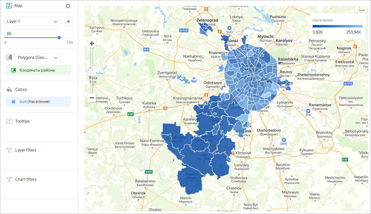
choropleth-map

Sections in the wizard

Section
in the wizard
Description
Polygons (Geopolygons) Measure with the type Geopolygon.
Colors Dimension or measure. Affects the color and intensity of area fill.
Tooltips Dimension or measure. A tooltip that appears when you hover over an area.
Layer filters Dimension or measure. Used as a filter for the current layer.
Chart filters Dimension or measure. Used as a filter for the entire chart.

Creating a choropleth map

  1. On the Yandex DataLens home page, click Create chart.
  2. Under Dataset, select a dataset for visualization. If you don't have a dataset, create one.
  3. Select the Map chart type.
  4. Select Polygons (Geopolygons) as the layer type.
  5. Drag a dimension with the Geopolygon type from the dataset to the layer type selection section.
  6. Color the polygons on the map. Move the measure or dimension to the Colors section.
  7. Add tooltips to show the dimension and measure values when hovering over a polygon.

You can also:

  • Add, rename, and delete a layer.
  • Apply a filter to the whole chart or one layer.

Recommendations

  • Don't use a choropleth map to precisely compare some values.
  • To make it more precise, add data signatures or pop-up hints with information to the map.

Was the article helpful?

Language / Region
Yandex project
© 2023 Yandex.Cloud LLC
In this article:
  • Sections in the wizard
  • Creating a choropleth map
  • Recommendations